Ko
Menu
English
Arabic
Brazil
French
German
Italian
Russian
Simplified China
Traditional China
Spanish
Turkey
India
Vietnam
Japanese
Korean
앱 정보
연락처
Ko
English
Arabic
Brazil
French
German
Italian
Russian
Simplified China
Traditional China
Spanish
Turkey
India
Vietnam
Japanese
Korean
This section is not available yet
홈
지도
맨 섬
St Johns
섹션
최고 장소
엔터테인먼트
공원
관광 명소
교회
기념비
비즈니스
숙박
캠핑
게스트하우스
상점
건강
식품
카페
펍
교육
학교
교통
금융
게스트하우스
Kerrowkeil Bed & Breakfast
1.5
공원
Tynwald National Park & Arboretum
German, St. Johns, Im4 3, 맨섬, GPS: 54.20399,-4.638849
Cooill Y Ree
맨섬, GPS: 54.203537,-4.643668
교회
St John's Methodist Church Hall
맨섬, GPS: 54.203022,-4.640804
The Royal Chapel Of St John The Baptist
Douglas Road, St Johns, 맨섬, GPS: 54.20333,-4.6402574
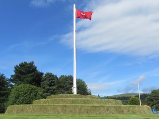
기념비
Tynwald Hill
Peel Rd (Glen Moar Rd), St Johns, 맨섬, GPS: 54.203594,-4.641123
카페
Tynwald Hill Cafe (Greens)
vegetarian $
Peel Road, St Johns, 맨섬, GPS: 54.20297,-4.641981
가격
야외 좌석
+
more
캠핑
Ballaspit
1.0
펍
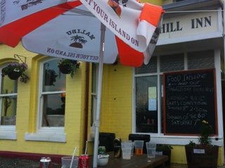
Tynwald Hill Inn
$
Main Road, Saint Johns, IM3 4NA, 맨섬, GPS: 54.20321,-4.642344
가격
신용카드
야외 좌석
+
more
학교
Saint Johns School
1.5
St John's School
맨섬, GPS: 54.201454,-4.639933
Show on map
Show list
MAPS.ME
휴대하세요
앱을 다운로드해 더 넓은 세상과 만나세요
MAPS.ME 앱 열기
웹 버전 사용