Ko
Menu
English
Arabic
Brazil
French
German
Italian
Russian
Simplified China
Traditional China
Spanish
Turkey
India
Vietnam
Japanese
Korean
앱 정보
연락처
Ko
English
Arabic
Brazil
French
German
Italian
Russian
Simplified China
Traditional China
Spanish
Turkey
India
Vietnam
Japanese
Korean
This section is not available yet
홈
지도
영국
Carnoustie
섹션
최고 장소
엔터테인먼트
도서관
공원
관광 명소
교회
비즈니스
숙박
아파트
게스트하우스
호텔
상점
슈퍼마켓
건강
개인 병원
약국
식품
펍
교육
학교
교통
주차장
택시
기차역
금융
개인 병원
Parkview Primary Care Centre
카누스티, Angus, 영국, GPS: 56.5004,-2.734402
게스트하우스
The Links View Holiday Home
Morven House
1.0
공원
House Grounds
1.5
교회
Carnoustie Church
2.0
Barry Parish Church
2.0
기차역
Carnoustie
2.5
Carnoustie
2.5
도서관
Carnoustie
영국, GPS: 56.50054,-2.7066412
슈퍼마켓
The Co-operative Food
1.5
The Co-operative Food
2.0
아파트
Henry Cotton Residence
Diamond - Links View Apartment
약국
Boots
3.1
76 Barry Rd, 카누스티, Angus, DD7 7QU, 영국, GPS: 56.500526,-2.7339272
신용카드
+
more
주차장
Black Slab
0.5
The Black Slab
영국, GPS: 56.49733,-2.7132514
택시
Station Road Taxi Rank
1.5
펍
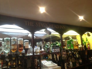
The Stags Head Inn
$$
Dundee Road, 카누스티, Angus, 영국, GPS: 56.500744,-2.722124
가격
+
more
Kinloch Arms Hotel
1.5
신용카드
+
more
학교
Carlogie Primary School
2.5
Burnside Primary School
2.0
호텔
The Station Hotel
$
23 Station Rd, 카누스티, Angus, DD7 6AR, 영국, GPS: 56.50087,-2.7067814
가격
+
more
19th Hole
카누스티, Angus, 영국, GPS: 56.50023,-2.7138567
Show on map
Show list
MAPS.ME
휴대하세요
앱을 다운로드해 더 넓은 세상과 만나세요
MAPS.ME 앱 열기
웹 버전 사용